Volume I, Issue 4
This issue of PJIM closes out our first full year of publication, and along with that milestone, four great works. Two essays in this issue discuss visualization of “spaces.” One work focuses on physical (e.g. a museum building) and another on imaginary (e.g. imagination scenarios) space. Each work delves into the concepts and methods of representing these different spaces in a similar manner—in these cases, via representational and descriptive objects of the original space.
Our other two essays discuss the elements of visual imagery and their effects on very expansive and globally-focused communities. One work speaks of the different social and cultural progression in two distinct religions as a result of cultural imagery. The other work discusses how a vast network of geographic imagery and information has defined communities and our global (or local) perception of them. Together these works exemplify the power of visualization and imagery and how important and powerful they are on our perceptions of communities and our involvement in those communities.
As we close out this first successful year of publication I speak for everyone at PJIM and thank our contributors and supporters for their effort and look towards many future years of collaboration.
Brian Willison, Publisher
Parsons Journal for Information Mapping
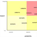
Imagining Possible Futures with a Scenario Space
by David Staley, PhD
Spatial Awareness and Exploration of the Museum Building
by Marcos Pereira Dias, MSc

Magnifying the Eye of Culture: Visual Cognition through a Comparative Sociocultural Progression of Christian and Islamic Image
by Veronika Tzankova & Thecla Schiphorst, PhD
Capturing Glocality: Part Two: Mapping Glocalities
by Katherine E. Behar, MFA, MA