Volume III, Issue 4

PJIM publishes articles that empower those who need to make content more relevant, more actionable, or simply more engaging for users. Our selections target method, analysis, or knowledge extraction—either in the general sense or for field-specific undertakings. For this issue we’ve touched on all three areas. One is an exploratory “light-capture” of bess beetles—generating both factual capture and the aesthetic elegance of their frozen movement; another brings attention to the effects of social, networked information on the whole process of art-making; next, a practical and powerful knowledge extraction engine that compares K through 12 education in selected markets; and, a visual comparison of diagrams to relational structures for the purpose of wayfinding through the NYC subway transit system via a station-to-station logic. As PJIM closes out our third year, and forty-eighth article, we wish to thank our submitters and readers for their efforts and their interest.

Jihoon Kang, Publisher, and William Bevington, Editor-in-Chief

Parsons Journal for Information Mapping

Dust: A Visualization Tool Supporting Parents’ School-Choice Evaluation Process

by Matteo Azzi, MSc, Giorgio Caviglia, MSc, Donato Ricci, PhD, Paolo Ciuccarelli, Emanuele Bonetti, MSc & Loredana Bontempi, MSc

The Public Interface as an Art-Making Enabler

by Winnie Soon, MA, MSc

New York City Transportation Mapping System

by Hannah Lea Dykast & Sarah Piper-Goldberg

Tracks Series: Visualizing the Travel Patterns of Bess Beetles

by Brittany Ransom, MFA

Dust: A Visualization Tool Supporting Parents’ School-Choice Evaluation Process

by Matteo Azzi, MSc, Giorgio Caviglia, MSc, Donato Ricci, PhD, Paolo Ciuccarelli, Emanuele Bonetti, MSc & Loredana Bontempi, MSc

KEYWORDS

Cartography, comparative education, data visualization, decision support, education, open data

ABSTRACT

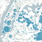
How does a parent choose the best school for their child? Dust is an ongoing research project developed for Iridescent, an American NGO. The project’s aim is to provide a freely available, web based information visualization tool that supports parents in exploring and comparing the educational offerings (from Pre-K to High School) from selected major cities in the United States, currently: New York, Los Angeles, and the San Francisco Bay Area. By leveraging a step-by-step decision making process, Dust helps to evaluate and compare school profiles based on multidimensional data-sets composed of general information (e.g., enrollment, class size, number of teachers), school performances (e.g., subjects score and proficiency, attendance), and urban mobility (e.g., location, distances, transportation). Supported by geographical maps and close-up visualizations users can create custom profiles based on their needs and priorities and then perform a search for the most appropriate schools for their children. Dust aims to combine the capability of information visualization in depicting synthetic views of complex, multidimensional, and georeferenced data; with a rich, yet intuitive, web-user experience. The project aims to move away from a “by experts, for experts” design paradigm to a schools comparison information visualization “for the people”—providing real impact on their daily life, and future prospects, through improved choices.

BIOGRAPHY

Matteo Azzi received his master’s degree in Communication Design in 2011. Currently Mr. Azzi serves as a researcher at the DensityDesign Lab. He specializes in the field of data and information visualization; Mr. Azzi’s interest has a heavy focus on the relationship between analog and digital environments within the interaction field.

Giorgio Caviglia has a master’s degree in Communication Design and is currently a PhD student in design at Politecnico di Milano. His research focuses on the study and the design of visualization tools for humanities and the social sciences disciplines. In 2008 he joined DensityDesign Lab. Currently, he is a teaching Assistant at the Politecnico di Milano and a visiting researcher for Stanford University.

Donato Ricci is a Senior Designer at DensityDesign Lab. In 2010 he earned a PhD degree summa cum laude in Industrial Design and Multimedia Communication at Politecnico di Milano with his dissertation “Seeing what they are saying: Diagrams for social complexity and controversies.” At DensityDesign Lab he carries out scientific research, design project fulfillment, and teaching activities in the field of visual epistemology. He is also Visiting Professor of Knowledge and Representation at the Universidade de Aveiro, Portugal.

Paolo Ciuccarelli is the founder and scientific coordinator of POLIteca, the Design Knowledge Centre of Politecnico di Milano. His research and publishing activities focus on the development of data, information and knowledge visualization tools and methods to support decision making processes in complex systems. In addition, Mr. Ciuccarelli serves as Associate Professor at Politecnico di Milano, teaching at the Faculty of Design in the Communication Design master degree. He has been visiting lecturer at Universidad de Malaga and The Royal Institute of Art (KKH, Stockholm).

Emanuele Bonetti is a graphic designer who earned his degree in Visual Communication Design at Politecnico di Milano. He worked in London before going to Rotterdam where he completed his master’s degree in Networked Media at the Piet Zwart Institute. He is a co-founder of parcodiyellowstone, a design collective. He pursues design with open source cultures, new media, and design ethics.

Loredana Bontempi received her bachelor degree in Visual Communication Design from Politecnico di Milano. She is a co-founder of the design group parcodiyellowstone. Ms. Bontempi graduated with a master’s Degree in Media Design and Communication from the Piet Zwart Institute in Rotterdam. Loredana currently works in Italy where she is further developing work concentrating on free culture and media design ethics.

The Public Interface as an Art-Making Enabler

by Winnie Soon, MA, MSc

KEYWORDS

Application programming interface (API), art culture, art making, cybernetics, data aesthetics, digital collaboration, interface, networking, open-source data, public interface, web communication, web connectivity

ABSTRACT

Cyberspace supports opportunities to capture cultures through machine and human interfaces. Art disciplines, particularly media arts, are not only enhanced by such a network of connectivity, they have become significantly changed through it. The Internet, as a public interface, is becoming the place to foster the development of media art disciplines. This is because the transmission and moving of data through the interface have permitted artists to develop new ways to capture, access, and select content. Well beyond simple conversations, networked information exchange and working transactions allow social issues and cultural production to be facilitated in a rich and transparent manner. Ultimately, this leads to new creations made fundamentally possible through the interface and its ease of use. From these resulting collaborations the interface can alter the way we understand “data” generated in the public domain. Via reuse and reproduction into another form the data is able to “live” again in many different ways respective to each artist’s, designer’s, and scientist’s reinterpretation. The public interface becomes a dynamic of network culture and further advances new levels for artistic and cultural purpose.

BIOGRAPHY

Winnie Soon is a transdisciplinary artist, researcher, and digital media practitioner born in Hong Kong. She completed her Information Systems Degree and Media Cultures Masters Degree at City University of Hong Kong. Ms. Soon was awarded with a scholarship and completed her second graduate degree in Digital Art and Technology at University of Plymouth (U.K.).

Ms. Soon investigates culture and data aesthetics through her work. Her artistic practice ranges from digital print, to interactive media, to installation art with an emphasis on the interplay between media, culture, and communication. Her artworks has been exhibited at IFVA (Hong Kong), Mobile & DMB Festival (South Korea), Stuttgarter Filmwinter Festival for expanded media (Germany), International Digital Art Festival (Bulgaria), Peninsula Arts Gallery (U.K.), and PhotoPark (China) amongst other locations.

She currently teaches at the Savannah College of Art and Design (Hong Kong) as well as the Chinese University of Hong Kong.

New York City Transportation Mapping System

by Hannah Lea Dykast & Sarah Piper-Goldberg

KEYWORDS

Collaborative projects, comparative efficiency, generation y usability, information mapping, navigation, Metropolitan Transportation Authority (MTA), New York City Transit, schematic, transportation, visual communication, wayfinding

ABSTRACT

Through the informal research of young adults who use New York’s Metropolitan Transportation Authority’s (MTA) subway system we were struck by their questioning of the relevance of the MTA’s geographicallybased subway map. It became evident that, as these members of society are heavily influenced by technology and technology savvy, their interest in a more rapid way to access and act upon transit information was of interest. We considered the importance of geography for communicating transit information to riders; perhaps this was not the ideal way to inform riders of train connections and context. Our hypothesis was confirmed after surveying a great deal of these people—we found that young adults connected to direct information available through technology do not rely on geography when navigating the NYC subway. Most young adults do not use the subway map to route their trips at all, instead they use an online application like Google Maps, MTA Trip Planner, or HopStop in order to enter the exact address of a departure and arrival destination. They trust the technology about which lines to take and how long it will take to get there. Once they are underground, young adults use a Smartphone app to make sure that they are on the correct lines and to check for any available transfer stops along the way. Instead of a physical map to support this rider workflow our goal was to create a schematic map that would be as easy to understand as any Smartphone app, such a schematic would allow users to focus in on their expected destinations and enable them to find available transfer stations throughout their journey. Our map was designed to be clear, simple, and easy to read; it would allow users to beneficially break away from the current NYC geographically-based subway map, a map which impacts users mindset through typical spatial notions.

BIOGRAPHY

Hannah Lea Dykast is a designer primarily working in the field of graphic design, ranging from: information design, branding, print, editorial and packaging, to motion, sound, and web. Born and raised in South Germany, Hannah received her Abitur/International Baccalaureate Degree in Germany before she came to New York where she is currently a senior in the BFA Communication Design program at Parsons The New School For Design.

Sarah Piper-Goldberg is a senior at Parsons the New School for Design, where she majors in Communication Design. Sarah hopes to create a visual language that benefits the world around her. She is interested in information design because it brings clarity to many complex issues and ideas through a plethora of interpretations.

Tracks Series: Visualizing the Travel Patterns of Bess Beetles

by Brittany Ransom, MFA

KEYWORDS

“Analog” tracking system, bess beetles, emergence, light emitting diodes, long exposure, photography, time-exposure photography, tracking

ABSTRACT

Track Series is an exploratory series of photographic, videographic, and motion capture images mapping the habitual travel patterns of bess beetles. In order to accurately capture such patterns the bess beetles are each affixed with their own trackable “backpack.” These are made from a self-adhesive hook and loop fastener, a small watch battery, and variable light-emitting diodes. Due to the beetle’s necessity to constantly burrow and make tunnels through hard woods, such as oak, elm, and other deciduous trees, these beetles have a unique, brute strength unrivaled by many other organisms. This allows them to carry their illuminated backpacks with little hindrance respecting their motion. This project is conceptually rooted to the notions of emergence, travel, and the revealing of formerly unrecognized path making. Additionally, it furthers the author’s persistent desire to collaborate (albeit uninvitedly) with insects.

BIOGRAPHY

Brittany Ransom is an artist and educator living and working in Chicago, Illinois. She recently received her Master of Fine Arts degree with a concentration in New Media Arts (formerly Electronic Visualization) from The University of Illinois at Chicago. She is currently a College Art Association Fellow, former two-time Lincoln Fellow, and recipient of the Provost Award at the University of Illinois at Chicago. Prior to her time in Chicago, Ransom was living in Columbus, Ohio. While in Columbus she participated in numerous exhibitions and worked as an exhibit technician at the Center of Science and Industry. She received her Bachelor of Fine Arts from The Ohio State University with distinction with a concentration in Art and Technology in 2008. Ransom is currently a Visiting Adjunct Professor and Artist in Residence at Southern Methodist University teaching Physical Computing in the Center of Creative Computation within the Department of Art in Dallas, Texas. Brittany has exhibited her work both nationally and internationally. Ransom is originally from Lima, Ohio.